Published: Friday, 18 September 2026, at 12:08 am| Dubai | Edited: Friday, 18 September 2026, at 12:18 am
Dubai new fourth corridor road project was officially announced by the Dubai government to streamline travel across the emirates. As someone who tracks regional transport updates closely, I found that this major highway expansion promises to cut journey times drastically for daily commuters. Read on to discover all the key details, route phases, and features of this groundbreaking project.
ALSO READ:
- Oman-UAE Rail Link 2027: Trial Operations, Routes, Speeds, and Launch Details
- How to Reach Dubai Outlet Mall: The Complete Travel, Shopping, and Dining Guide
- Abu Dhabi Airport to Dubai Bus Timing: Schedules, Fares, & Travel Guide (2026)
Dubai New Fourth Corridor Road Project: Complete Route and Phase Guide
Comprehensive guide to the 80km highway linking Sharjah, Dubai, and Abu Dhabi.

Crown Prince Sheikh Hamdan bin Mohammed bin Rashid Al Maktoum approved this massive strategic initiative to strengthen inter emirate connectivity.
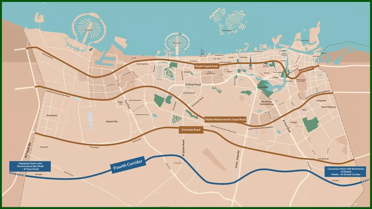
- Strategic Significance: Serves as the fourth major corridor connecting the emirates, joining Sheikh Zayed/Al Ittihad Road, Sheikh Mohammed bin Zayed Road, and Emirates Road.
- Economic Boost: Facilitates smooth commercial and logistics transport across key economic zones.
- Urban Support: Keeps pace with rapid urban expansion and long term population growth.
Route Overview and Strategic Connections
Key landmarks and geography along the 80km stretch.
From my route analysis, this project links major national developments while diverting heavy through traffic away from congested city hubs.
- Start and End Points: Connects Al Shanouf Road in Sharjah directly to Al Faya Road in Abu Dhabi through Dubai.
- Landmarks Served: Passes through Al Maktoum International Airport, Al Marmoom Desert Conservation Reserve, and Al Wohoosh Desert Conservation Reserve.
- Multimodal Links: Integrates seamlessly with the Etihad Rail network and key residential development communities.
Fourth Corridor Phase 1 Details
First 30km stretch specifications and investments.
The initial stage focuses on creating high capacity transit between Sharjah and central Dubai routes.
- Route Coverage: Covers approximately 30km from Al Shanouf Road in Sharjah to Dubai–Al Ain Road.
- Investment: Costs around Dh3.5 billion for complete construction.
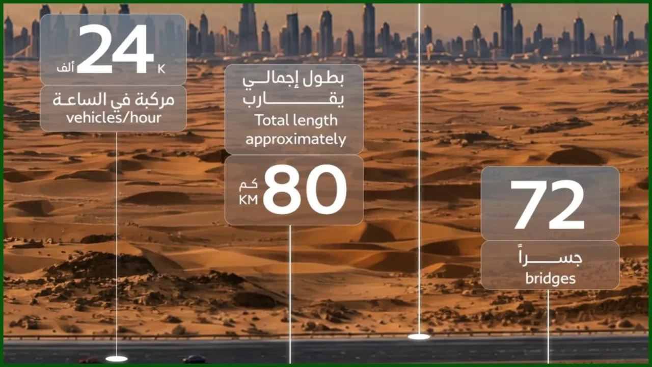
- Road Capacity: Features a 12 lane through corridor carrying up to 24,000 vehicles per hour in both directions.
- Population Reach: Serves an estimated 600,000 residents once fully operational.
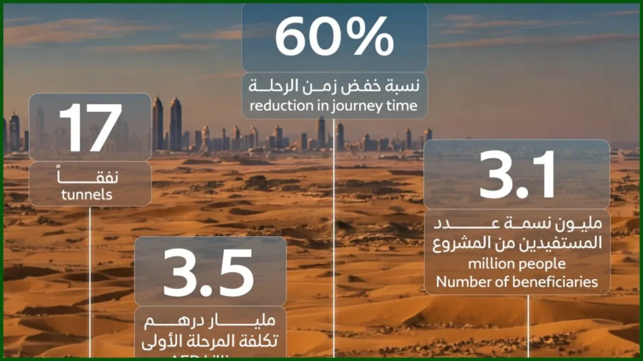
- Time Savings: Reduces journey times by 60 %, turning a 35 minute commute into just 14 minutes.
- Infrastructure Specs: Includes 55 lane kilometres of at grade roads, 2.5km of tunnels, and 21km of bridges and ramps.
- Road Upgrades: Widens Dubai–Al Ain Road from three to four lanes in each direction between Emirates Road and Lehbab Road, alongside upgrades to four major intersections.
ALSO READ:
- Uber Apollo Go Dubai Driverless Taxis Launched: Here Is How to Book Your Ride
- Etihad Rail Banned Items & Luggage Allowance: Everything You Need to Know Before You Travel
Fourth Corridor Phase 2 Features
Second 50km extension details and reach.
The second stage extends the highway seamlessly towards the Abu Dhabi border to ease regional travel.
- Route Coverage: Extends 50km to connect Dubai–Al Ain Road with Al Faya Road in Abu Dhabi.
- Capacity: Features 12 lanes across both directions handling 24,000 vehicles per hour.
- Time Savings: Cuts travel time by 52%, reducing a 50 minute journey down to 24 minutes.
- Population Reach: Serves approximately 3.1 million people across expanding districts.
- Infrastructure Specs: Includes 190 lane kilometres of at grade roads, 3.5km of tunnels, and 157km of bridges and ramps.
Traffic Relief and Engineering Scope
Total structural components and congestion management.
I noticed that the design places heavy emphasis on structural excellence to eliminate bottle necks across urban zones.
- Structural Highlights: Incorporates a grand total of 72 bridges, 17 tunnels, and 45 stormwater drainage culverts.
- Truck Diversion: Redirects heavy freight trucks away from city streets to boost overall road safety.
- Network Relief: Relieves heavy pressure on existing routes like Sheikh Mohammed bin Zayed Road and Emirates Road.
Phase Comparison Overview
Direct comparison of Phase 1 and Phase 2.
To help you understand how each stage unfolds, here is a breakdown comparing the key parameters of both construction phases.
| Feature | Phase 1 | Phase 2 |
| Distance | 30km | 50km |
| Connects | Al Shanouf Rd to Dubai–Al Ain Rd | Dubai–Al Ain Rd to Al Faya Rd |
| Travel Time Cut | 35 mins to 14 mins (60% cut) | 50 mins to 24 mins (52% cut) |
| People Served | 600,000 residents | 3.1 million residents |
| Cost / Scope | Dh3.5 Billion | Full 12 lane extension |
ALSO READ:
- From Machboos to Ghaf Juice Shots: Etihad Rail Launches Cultural Onboard Food Menu
- How to renew Dubai Driving License in 2026: RTA App, Eye Test, Fees, Kiosk & Fine Clearance Guide
Conclusion
This ambitious highway project will reshape regional travel, making everyday commutes faster and far safer for everyone in the UAE.
FAQs
What is the total length of the New Fourth Corridor?
The entire highway stretches approximately 80km across the emirates.
Which emirates does the new corridor connect?
It directly connects Sharjah, Dubai, and Abu Dhabi.
How much travel time will Phase 1 save?
Phase 1 reduces a 35 minute journey down to 14 minutes.
How many lanes will the new corridor feature?
The corridor features 12 lanes in total across both directions.
Will the corridor handle heavy cargo transport?
Yes, it diverts heavy trucks away from crowded urban centers.